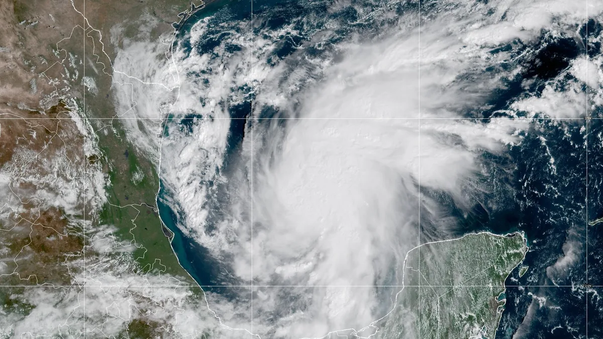
Isaias left 2 to 2.5 inches of rain across Atlanta and a 47 mph gust at Hartsfield-Jackson, weather service reports show. Storm totals and the forecast.
Updated Oct. 17: the storm has passed. Rain and wind totals from the National Weather Service are below. The forecast published Oct. 7 follows them.
What Isaias brought to Atlanta
Gauges across Atlanta recorded between 2 and 2.5 inches of rain from Isaias. The strongest gusts came overnight Friday into Saturday. The figures come from two public information statements the National Weather Service in Peachtree City issued Sunday afternoon, Oct. 11: one for rainfall and one for peak winds. They are preliminary reports from gauges and observers, and the rainfall list includes only totals of 2 inches or more.
Storm-total rain at gauges in Atlanta:
| Gauge | Rain |
|---|---|
| South River at Forest Park Road | 2.51 inches |
| Atlanta Fire Station 10 | 2.22 inches |
| Hartsfield-Jackson Atlanta International Airport | 2.13 inches |
| Ansley Golf Club | 2.10 inches |
| Mercedes-Benz Stadium | 2.06 inches |
| Peachtree Creek at Northside Drive | 2.04 inches |
The highest total on the weather service’s list was 4.39 inches, near the Georgia International Horse Park in Conyers, about 29 miles east.
Peak wind gusts in and near Atlanta:
- 47 mph at Hartsfield-Jackson at 3:24 a.m. Saturday, Oct. 10
- 44 mph at Fulton County Airport-Brown Field at 5:24 a.m. Saturday
- 43 mph at the Georgia Tech observatory at 11:23 p.m. Friday, Oct. 9
- 35 mph at DeKalb-Peachtree Airport at 3:17 a.m. Saturday
The forecast before the storm
Tropical Storm Isaias could bring heavy rain, flash flooding, gusty winds and a few tornadoes to metro Atlanta from Friday evening into Sunday. The storm is expected to become a strong hurricane before it reaches the northern Gulf Coast late Friday.
The National Weather Service in Peachtree City, which forecasts for Atlanta, said in its Hazardous Weather Outlook Wednesday morning, Oct. 7, that impacts were possible across north and central Georgia. It said uncertainty “remains high.” No watch or warning covers Atlanta yet.
Where the storm is now
At 11 a.m. ET Oct. 7, Isaias was about 540 miles south-southwest of the mouth of the Mississippi River. It had top sustained winds near 45 mph and was moving east-northeast at 8 mph. That is from the National Hurricane Center’s Advisory No. 4.
The center said rapid strengthening is forecast and Isaias is expected to become a hurricane by Thursday. Its forecast discussion calls for a “strong hurricane” approaching the northern Gulf Coast on Friday. The forecast track then takes the storm inland over Alabama by Saturday morning.
Watches issued Oct. 7 on the coast:
- Hurricane watch: Bay St. Louis, Mississippi, to Indian Pass, Florida
- Storm surge watch: the mouth of the Mississippi River to Yankeetown, Florida
- Tropical storm watch: the Jefferson/Plaquemines Parish line in Louisiana to west of Bay St. Louis, and east of Indian Pass to the Aucilla River in Florida
What the forecast says for Atlanta
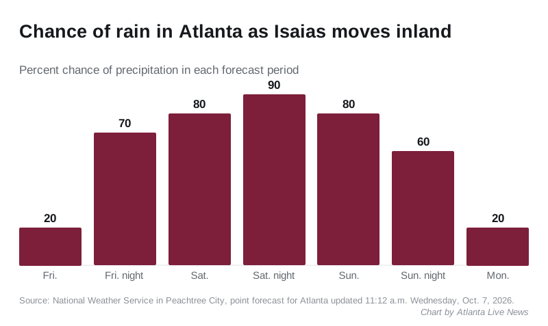
The weather service’s point forecast for Atlanta stays dry and warm through Thursday, with a high near 86. Rain arrives Friday night:
- Friday: a slight chance of showers after 2 p.m., high near 82, gusts as high as 20 mph
- Friday night: showers likely, 70% chance
- Saturday: showers, then thunderstorms after 2 p.m., high near 73, 80% chance
- Saturday night: showers and thunderstorms, 90% chance
- Sunday: showers and thunderstorms, high near 78, 80% chance
- Monday: a slight chance of storms, 20%
How much rain
The hurricane center expects 1 to 3 inches of rain across much of the Southeast, as far north as the Tennessee Valley and the Carolinas. Some spots could see up to 5 inches. It said flash and urban flooding, and isolated river flooding, will be possible.
The Peachtree City office said in its forecast discussion that widespread rainfall “seems almost certain.” Its model blend gives a 70% chance of at least 1 inch of rain over nearly all of north and central Georgia.
The forecasters said three questions will decide what Atlanta gets:
- how far east the storm makes landfall
- how strong it is when it turns north
- how much eastward momentum it carries inland
A more eastern track would put metro Atlanta closer to the storm’s right front side, where tornadoes are more likely, the office said. A storm that stalls after landfall could raise the flood and tornado risk.
Wind
The hurricane center’s wind probability table does not list Atlanta. Columbus, about 100 miles southwest, has an 8% chance of tropical-storm-force winds through Monday. Albany has a 5% chance. The Peachtree City office said gusty winds are possible locally.
What it means for you
- Power: if the lights go out, our power outages page has the Georgia Power numbers and outage map.
- Flooded roads: the weather service’s advice is Turn Around, Don’t Drown. Never drive into water covering a road.
- Hurricane season runs through Nov. 30. Forecasts for Atlanta come from the Peachtree City office.
Have your say